
Aerial and Drone Services
Orthomosaics, 3D Models, Photogrammetry, Mapping, Still and Video.
Drone Photography and Videography.
Aerial photography and videography is a specialised area of image capture. Rafael Photography has over 6 years experience on rotary aircraft as a platform for aerial photography and videography. Rafael works in both remote and urban locations shooting imagery for mining, shipping and transport, construction progression to Project Completion, environment management, agricultural and real estate. Rafael is also a CASA registered and fully insured Drone operator for sub 7kg drone work, shooting both stills and video for clients in the mining, construction, transport, commercial real estate and agricultural industries. To discuss your next aerial or drone project contact Rafael Photography.
CASA Certified: AROC, RePL and ReOC
ARN Number: 1210973

Orthomsaics (Maps).
Orthomosaic maps are made from a number of aerial photographs stitched together to make up a high resolution larger detailed map of your job area. Each aerial photograph is pinned to a geographic location with altitude data. this allows the client to not only see progress of their job, but also extract valuable information such as distances, areas, and volumes of stock piles, point-cloud data, imagery, Digital Surface/Terrain Models, GIS data or metadata. Moreover, the images can also be stitched in 3D terrain models and job fly-though, making in an invaluable tool for your clients.
Rafael Photography can produce high resolution orthomosaic maps of your job site area of interest with a turn around time of less than 48 hours depending on the area, using the most up to date OH&S regulations. .
Why Drones Over Planes & Satellites
Drones are cheaper and better for aerial photography than planes or helicopters and satellite images. They can take high-quality pictures whenever needed, and they aren't affected by clouds..

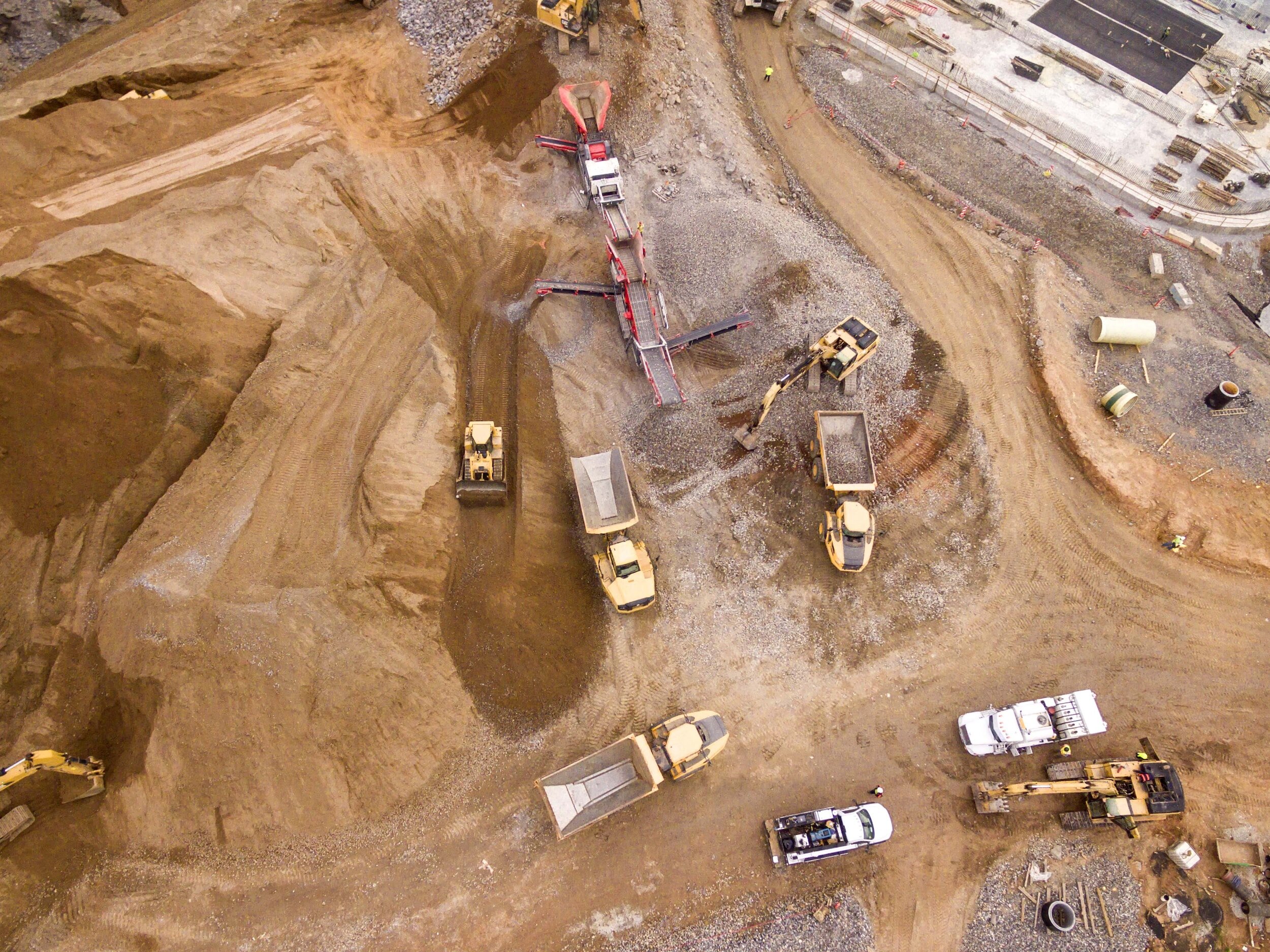
Construction
Drones can be used to get fortnightly/monthly site fly-over videos and aerial photography for progress reporting. They are also used to measure volumes of gravel is in a stockpile, or to fly around a structure and construct a 3D model of it using photogrammetry. Other services within construction can include surveying lands, access to areas that are dangerous for people or difficult to access for traditional vehicles, superimpose current progress to future/past plans, adding visual method to showcase progress to the clients who may not be able to go to site and compliance reporting.
Rafael Photography can use both drones and other land based cameras to produce detailed descriptions of the job site in aiding progress and safety reports. We will come to your site with appropriate PPE, and equipment to perform the task. We have a number of local industry inductions, MSIC, Construction White Cards etc.

Safety
Accessing areas too dangerous for workers, better surveillance as the eyes are in the sky – on level with works in high areas

Agriculture, Farming & Environment
Normal cameras record images in three bands of the visible spectrum – red, green, and blue. By comparison, a multi-spectral camera captures many bands in the visible and near-infrared portions of the spectrum, providing far more detail than the human eye can see. Drones are now capable of carrying small versions of these incredible cameras and this allows for the classification of different kinds of crop or vegetation type. Every object gives off a unique multi-spectral signature, kind of like a human fingerprint. A diseased plant gives off a different signature than the equivalent healthy one. this technology can be used for a number of agriculture and farming practices as well as environmental assessment such as forestry, coastal erosion and management and much more.
Rafael Photography owns and operates multi-spectral drones with the capacity to photograph in the visible, near-red and Near Infra-red spectrum, allowing detailed construction of maps and images using different vegetation indices to determine plant and crop health. Moreover, software can be used to determine quick large scale seed and crop/plant counts as well as diseased, low germination areas.

Asset Inspections
Bridges, towers, solar panels, wind turbines… Many outdoor structures need to be inspected at least once a year. Drones replace cranes and EWP’s and allow for faster, safer and more detailed high- res images of these assets

Real Estate Photography/Videography
Aerial photography captures your house and property, garden, pool, and water views . Drones are known for taking more captivating photos of houses and land for sale. They can fly over empty lots or construction sites and take 360-degree shots that show the future view before the building is done. Drones are also useful for inspecting roofs and assessing insurance claims.
Rafael Photography has a number of drones and camera equipment to aid in the aerial view of home and land parcels, and or industrial sites, allowing for stunning real estate still and video production and marketing porposes.
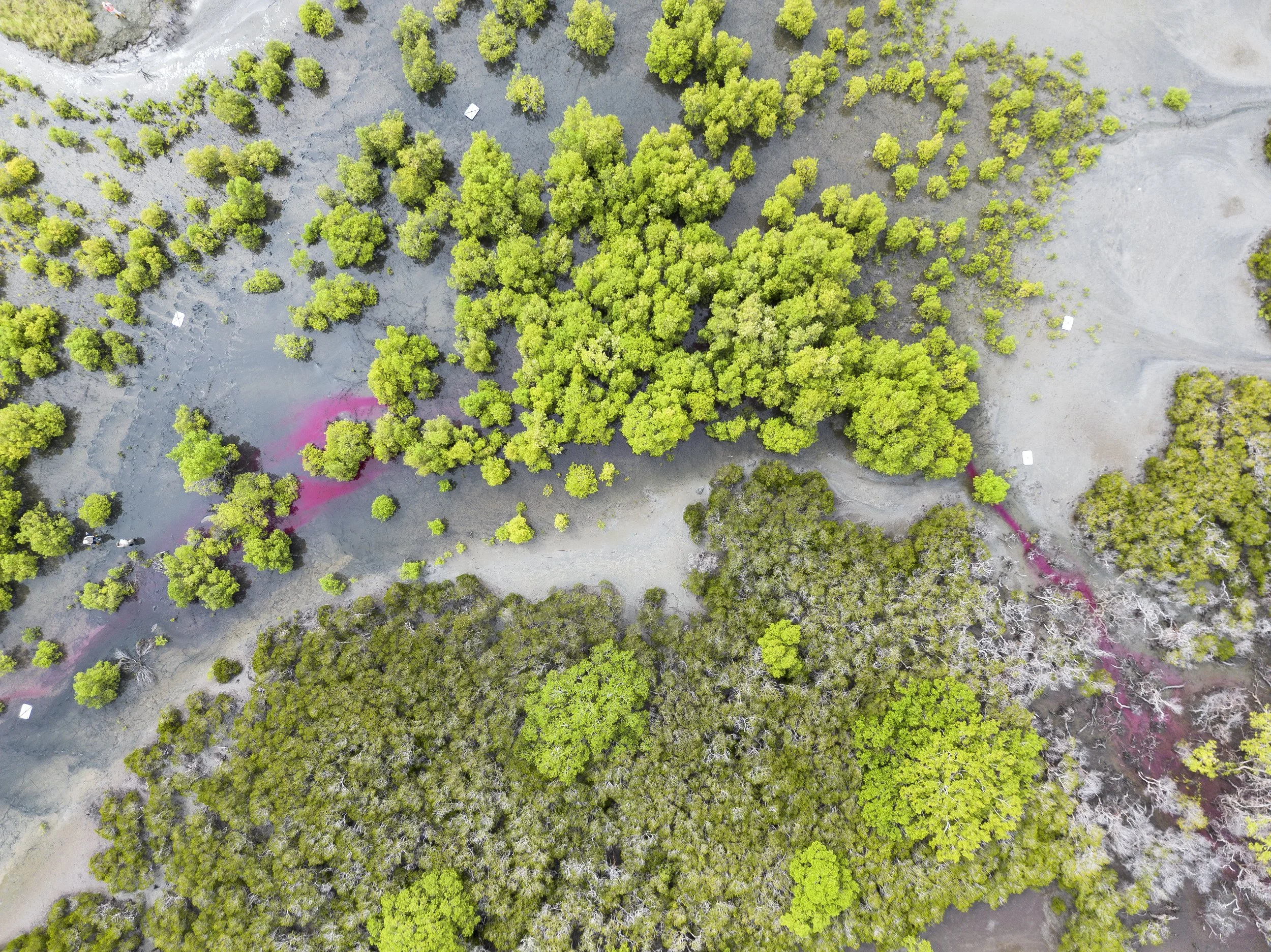
CASE STUDY
Inert environmentally friendly fluorescent tracer was used to track water flow through a mangrove forest to determine cause of dieback using drones, ground control points and photogrammetry

Aerial footage of mangrove forests in Queensland. Video promotion for client